Section outline


    • Sl

      Assessment techniques

      Marks

      1

      Class Attendance

      5

      2

      Class Test

      15

      3

      Assignment

      5

      4

      Lab

      25

      5

      Midterm Examination

      20

      6

      Final Examination

      30

      Total

      100


    • What is remote sensing and what is it used for?

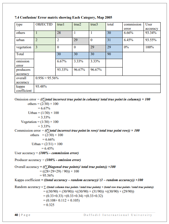
      Remote sensing is the process of detecting and monitoring the physical characteristics of an area by measuring its reflected and emitted radiation at a distance (typically from satellite or aircraft). Special cameras collect remotely sensed images, which help researchers "sense" things about the Earth. Some examples are:

      • Cameras on satellites and airplanes take images of large areas on the Earth's surface, allowing us to see much more than we can see when standing on the ground.
      • Sonar systems on ships can be used to create images of the ocean floor without needing to travel to the bottom of the ocean.
      • Cameras on satellites can be used to make images of temperature changes in the oceans.

      Some specific uses of remotely sensed images of the Earth include:

      • Large forest fires can be mapped from space, allowing rangers to see a much larger area than from the ground.
      • Tracking clouds to help predict the weather or watching erupting volcanoes, and help watching for dust storms.
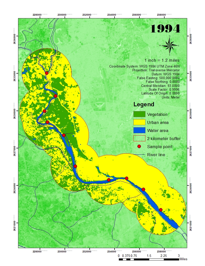
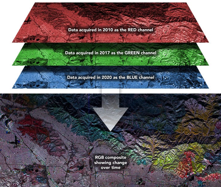
      • Tracking the growth of a city and changes in farmland or forests over several years or decades.
      • Discovery and mapping of the rugged topography of the ocean floor (e.g., huge mountain ranges, deep canyons, and the “magnetic striping” on the ocean floor).


    • Link for earth explorer

      https://earthexplorer.usgs.gov/

    • SEE THE PROCESS OF ARC GIS SOFTWARE INSTALATION HERE

    • Remote sensing ppt file

    • What is classification?
      What is supervised classification

    • A buffer is a reclassification based on distance:  classification of within/without a given proximity. 

      •  Buffering involves measuring distance outward in directions from an object.  Buffering can be done on all three types of vector data: point, line, area.  The resulting buffer is a polygon file.
      •  Most often buffers are measured in uniform distance. For example, creating a 50′ buffer around all rivers.  A buffer based on different distances is called a variable buffer.  For example, the noise level surrounding surround a street network may be based on the traffic load.  Therefore a variable buffer may be used to illustrate the noise level by using a larger distance for high traffic roads and a shorter distance for quieter roads.

      Download The File For More Information


    •    


    • Describe theses following contents and submit it in the assignment submission section bellow.

       Normalized Satellite Indexes

      • NDWI - Normalized Difference Water Index
      • NDVI - Normalized Difference Vegetation Index
      • GDVI - Generalized Difference Vegetation Index
      • NDSI - Normalized Difference Snow Index
      • NDSI - Normalized Difference Soil Index
      • NDMI - Normalized Difference Moisture Index
      • NDCI - Normalized Difference chlorophyll index
      • NBR - Normalized Burn Ratio
      • VARI - Visible Atmospherically Resistant Index

    • Opened: Thursday, 10 August 2023, 12:00 AM
      Due: Sunday, 24 September 2023, 12:00 AM

    • Supervised Image Classification

      The method used here to identify and calculate the land cover amount of the study area. In this process researcher manually input some supervised samples in ArcGis software, later the software itself calculate the pixel of the image data and shows the output. The amount of land cover uses of an area can be calculated by the help of production. In this case, the land cover shows the amount of increase or decrease meant for a particular land cover category.

      Unsupervised image classification

       Unsupervised image classification is the process by which each image in a dataset is identified to be a member of one of the inherent categories present in the image collection without the use of labelled training samples.


    •   


    • What is Shapefile?

      A shapefile is a simple, nontopological format for storing the geometric location and attribute information of geographic features. Geographic features in a shapefile can be represented by points, lines, or polygons (areas). The workspace containing shapefiles may also contain dBASE tables, which can store additional attributes that can be joined to a shapefile's features.


      Download the Shapefile from the link

      https://drive.google.com/drive/folders/1_4dFvhworwX_o4kUDcTvqvCoV6RNqkcT?usp=sharing


    •  


    • Following topics are included in this class

      • making composite band
      • clipping image
      • supervised image classification
      • unsupervised image classification
      • area calculation
      • Raster to polygon
      • dissolve tool
      • Selection and making layer
      • calculating layer
      • intersection of layer

      Class link

      https://drive.google.com/file/d/1FVBPRompqZs8sR6-opJeidyJ_KOrhiiX/view?usp=sharing

    • What does "georeferenced" mean?

      Georeferencing means that the internal coordinate system of a digital map or aerial photo can be related to a ground system of geographic coordinates. A georeferenced digital map or image has been tied to a known Earth coordinate system, so users can determine where every point on the map or aerial photo is located on the Earth's surface. 

      The relevant coordinate transforms are typically stored within the image file (GeoPDF and GeoTIFF are examples of georeferenced file formats), though there are many possible mechanisms for implementing georeferencing.  Georeferencing in the digital file allows basic map analysis to be done, such as pointing and clicking on the map to determine the coordinates of a point, to calculate distances and areas, and to determine other information.


    • Climate data link

      https://power.larc.nasa.gov/data-access-viewer/


    • Please Download through the link, as the file size is too big to upload directly

      Use your University mail to download


    • Opened: Monday, 20 November 2023, 12:00 AM
      Due: Saturday, 25 November 2023, 12:00 AM